Tag: town planning

The battles, feuds, and decisions that shaped the physical layout of Royal Tunbridge Wells — from 17th-century hilltop rivalries to Victorian railway politics.

  • Tunbridge Wells Railway War – Part 2

    Tunbridge Wells Railway War – Part 2

    Bombs, Bureaucrats, and a Toilet Block with a Removal Clause

    Building Files, Issue 3 (continued)


    When the Southern Railway took ownership of both Tunbridge Wells stations in 1923, it inherited a peace that nobody had quite asked for. Two stations, one tunnel, decades of simmering antagonism — all of it now tidied away into a single company balance sheet. The railway war was over. What followed was something quieter, and in some ways stranger: a slow, incremental dismantling of everything the LBSCR had built.

    It took sixty years. It involved a German bomb, a supermarket, and a toilet block whose planning permission came with the most unusual clause in Tunbridge Wells history.


    20 November 1940

    The Luftwaffe was not, as a rule, targeting railway engine sheds in medium-sized Kent spa towns. However, on 20 November 1940, a bomb found the locomotive shed at Tunbridge Wells West anyway.

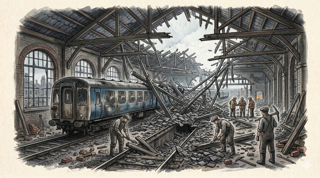
    The damage was significant. The original Victorian slate roof — laid in 1891 when the LBSCR expanded the depot to four roads — was destroyed. British Railways replaced it with corrugated asbestos sheeting. This was, in the fullest sense, a wartime solution: functional, immediate, and utterly without grace.

    The great red-brick engine shed survived. It still stands today, its arched windows intact, its Victorian bones unshaken. The asbestos roof is long gone. However, on the night of November 20th 1940, nobody was thinking about the long term. They were thinking about getting the trains running again.

    The Slow Decline

    The post-war decades were not kind to Tunbridge Wells West. Meanwhile, Tunbridge Wells Central — the SER’s station, the one that had won the first round of the rivalry in 1845 — was electrified in 1986 and went from strength to strength.

    West was a different story. It served the Wealden villages, the Groombridge valleys, and the old LBSCR lines through the High Weald. These were lightly used routes, operating on a shoestring. By the early 1980s, the track needed relaying, the signalling needed replacing, and British Railways had run the numbers.

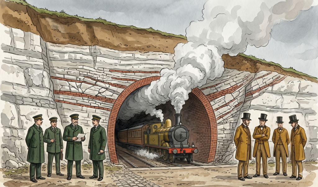
    The conclusion was blunt: keeping the line from Eridge to Grove Junction open would cost £175,000 a year more than it earned. Furthermore, the planned electrification of the Tonbridge to Hastings line required the removal of Grove Junction — the very connection that had been bored through the hillside in 1876 as the price of peace between two Victorian rivals. Therefore, the junction would go. And without it, Tunbridge Wells West was an island.

    British Railways announced closure on 16 May 1983. Local objections were strong enough to delay it. In February 1985, the Secretary of State for Transport confirmed the decision. The last passenger service ran on 6 July 1985.

    It is reported that as the final train crossed Grove Junction that evening, the permanent way team was already waiting on the other side with tools in hand. The track was lifted the following morning. After 119 years, the LBSCR’s line into Tunbridge Wells was gone.

    The Group That Named Itself TWERPS

    Six weeks later, on 13 September 1985, a meeting was held in Groombridge village hall. The mood, one imagines, was determined rather than cheerful.

    The people in that room formed a charitable society to do something that British Railways had just declared economically indefensible: reopen the line. They named themselves the Tunbridge Wells and Eridge Railway Preservation Society. The acronym, as the Spa Valley Railway’s own history notes, was chosen by people who were “blissfully unaware of the fact that anyone would use such an acronym to poke fun at them.”

    TWERPS it was. And TWERPS they remained.

    The Sainsbury’s Compromise

    The next few years were hard. Vegetation reclaimed the trackbed. The station buildings sat derelict. Then, in the late 1980s, the situation became dramatically more complicated.

    Tunbridge Wells Borough Council granted planning permission for a large Sainsbury’s supermarket complex on the site of the former goods yard at Tunbridge Wells West. The goods shed was demolished. The signal boxes vanished. The former stabling sidings disappeared under concrete and car parking. A Homebase arrived next door.

    However — and this is where the story acquires its most distinctly Tunbridge Wells character — the planning permission came with conditions.

    The 1891 locomotive shed was a listed building. So was the station itself. They could not be touched. Furthermore, the council negotiated a formal agreement with Lord Sainsbury: a corridor would be preserved alongside Linden Park Road, sufficient for a reinstated railway line to pass through the site. And if, at any future point, the railway returned and any Sainsbury’s building stood in its way, the company would remove it at their own cost.

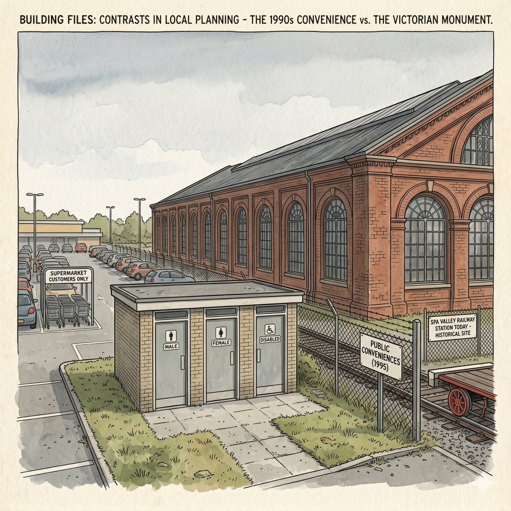
    In the mid-1990s, a toilet block was built on this corridor. It stood in the path of the railway. It could, under the terms of the agreement, be demolished.

    A toilet block with a legally binding removal clause. In Tunbridge Wells. Where else.

    The Return

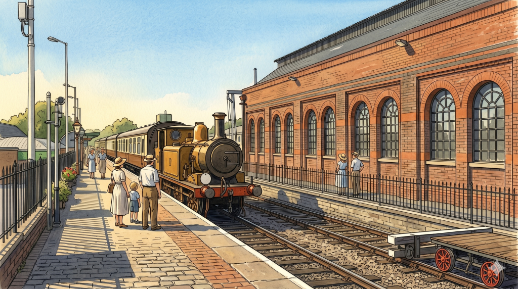
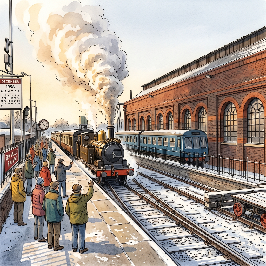
    In 1994, with a loan from Tunbridge Wells Borough Council, TWERPS acquired the line. In December 1996 — eleven years after closure — the first heritage train ran from the restored station at Tunbridge Wells West toward Groombridge, hauled by a steam locomotive called North Downs. Services reached Groombridge in August 1997, Birchden Junction in 2005, and Eridge in March 2011.

    The spur to Grove Junction — the peace tunnel itself, the single track bored through the hill in 1876 — was sold for £1 in 2001 to Railway Paths Ltd, a subsidiary of Sustrans. It is protected by covenant: the land can only ever be used for railway purposes. It is safeguarded in the East Sussex Structure Plan. It sits there now, overgrown, waiting.

    The great engine shed has been restored. The platform is busy on summer weekends. Steam trains run through the High Weald to Eridge, through Groombridge and High Rocks, through the same countryside the LBSCR carved its route through in 1866.

    What Remains

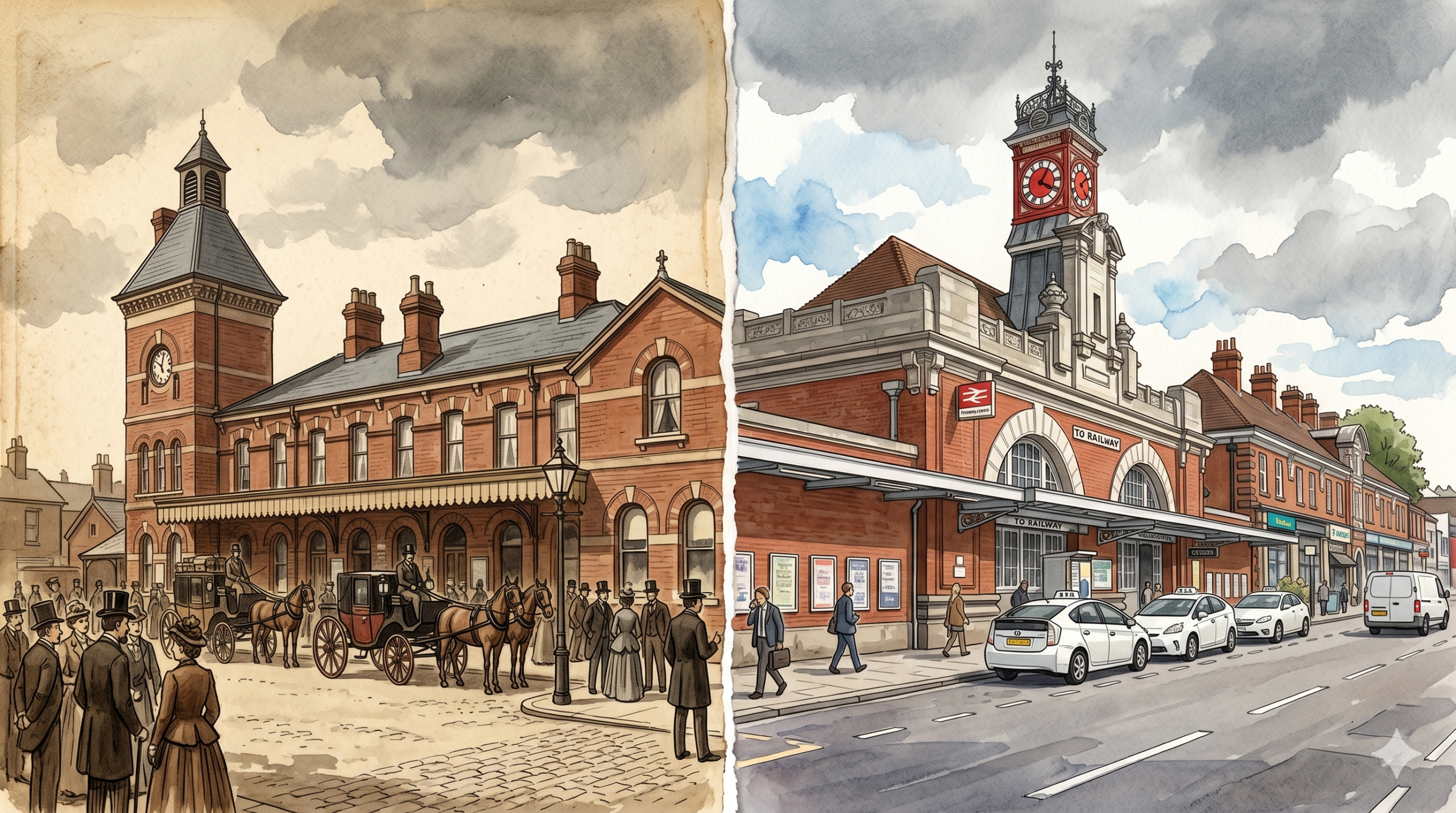
    Tunbridge Wells Central — SER territory, always, is a busy commuter station. Southeastern trains to London Charing Cross, London Bridge, and Hastings. The clock tower that appears in the Victorian photographs still stands above the forecourt. The taxis queue where the horse-drawn carriages once waited.

    Tunbridge Wells West is something different: a working museum, a community project, and an argument that some things are worth keeping not because they are profitable but because they are loved.

    The two stations began as enemies. They ended as a pair of complementary survivors — one thriving on the main line, one thriving on nostalgia, volunteer labour, and the particular stubbornness of people who name their campaign group TWERPS and mean it.

    The railway war ended in 1923. The railway, however, did not.


    The Building Files is a WalkTW series exploring the hidden histories of Royal Tunbridge Wells’s most interesting addresses. Grove Tunnel remains intact beneath Grove Hill, sealed but structurally sound, its Victorian brickwork still in place.

  • Tunbridge Wells Railway War — Part 1 (1845–1923)

    Tunbridge Wells Railway War — Part 1 (1845–1923)

    Two Companies, One Town, Zero Diplomacy

    Building Files, Issue 3


    There are towns in England where the railway arrived, and everyone was grateful. Royal Tunbridge Wells was not one of those towns. Here, the railway arrived twice — brought by two rival companies who despised each other — and the resulting feud shaped the town for the better part of a century.

    It began, as most Victorian problems did, with money, ambition, and a complete absence of goodwill.


    The First Arrival

    The South Eastern Railway reached Tunbridge Wells on 20 September 1845. This was not, it has to be said, a triumphant entry. The line ran from Tonbridge and terminated at a temporary station called Jackwood Springs, on the northern fringe of town. It was essentially a shed. For over a year, passengers alighted into what amounted to a field.

    The proper station — what would eventually become Tunbridge Wells Central — opened on 25 November 1846, once the Wells Tunnel had been excavated beneath the town. The SER now had a foothold. More importantly, it had ambitions. Hastings was next on the agenda, and after that, potentially, Lewes.

    This was when the trouble started.


    Enter the Rival

    The London, Brighton and South Coast Railway had been watching the SER’s southward expansion with the kind of alarm that polite Victorians expressed through Parliamentary bills rather than raised voices. The SER’s push toward Hastings threatened LBSCR territory. A line toward Lewes would be a direct invasion.

    So the LBSCR drew up plans for its own line into Tunbridge Wells — from the west, via Groombridge — and obtained Parliamentary authorisation on 7 August 1862. After three separate Board of Trade inspections (the Victorian equivalent of a zero-star hygiene rating), the line finally opened on 1 October 1866.

    Tunbridge Wells now had two railway stations. They belonged to two companies that, for all practical purposes, regarded each other as enemy combatants.


    The Tunnel Nobody Wanted to Build

    The Tunnel Nobody Wanted to Build

    Having two stations in a town is only useful if passengers can get between them. The two companies had no particular desire to help each other’s customers. However, Parliament had other ideas.

    The SER was eyeing a new line to Eastbourne, which would have cut directly into LBSCR territory. Rather than fight that battle in the courts, the LBSCR made a calculation: build a connecting spur between the two stations, give the SER access to the Eastbourne route it wanted, and get them to back off.

    The result was the Grove Tunnel — a short, single-track connection bored through the hillside between the two stations. It opened for goods traffic in 1866 and for passengers on 1 February 1876. For the first time, a through service was possible between the SER’s Hastings line and the LBSCR’s routes to Lewes and the South Coast.

    It was, in the most literal sense, a peace tunnel. Dug under Grove Hill to connect two companies that still, fundamentally, did not trust each other.

    Through it ran trains from Charing Cross to Eastbourne — via a negotiated compromise buried twenty feet underground.


    Rivals on Paper, Neighbours in Practice

    The peculiar thing about the Tunbridge Wells railway war is how theatrical it was. The two stations sat less than half a mile apart. Passengers transferring between them could walk the distance in ten minutes. However, for most of the Victorian era, the official position of both companies was that no such transfer was necessary, because neither route needed the other.

    In practice, the town required both. Tunbridge Wells West served Brighton, the South Coast, and the Wealden villages. Tunbridge Wells Central served London, Hastings, and Kent. Together, they gave the town remarkable connectivity. Apart — which they mostly insisted on being — they were a logistical inconvenience for anyone whose journey required both.

    Meanwhile, the town’s population was growing rapidly. Tunbridge Wells was becoming a prosperous commuter destination. More trains, more routes, and more passengers meant that the rivalry was increasingly expensive for both sides.


    The Long Road to the Grouping

    By the turn of the twentieth century, the SER and LBSCR had each worn themselves down. The SER had already merged its operations — though not its legal identity — with the London, Chatham and Dover Railway in 1899, creating the South Eastern and Chatham Railway. The LBSCR carried on independently, but the Victorian era of aggressive expansion was essentially over.

    For Tunbridge Wells, this meant a period of relative stability. Two stations, one tunnel, and a grudging peace. Trains ran through Grove Tunnel with increasing regularity. At its peak, Tunbridge Wells West handled more than a hundred trains per day — a figure that would have seemed extraordinary to the two sets of company directors who had spent decades trying to exclude each other from the town.

    The formal end of the war came not with any local drama, but with an Act of Parliament. The Railways Act 1921 reorganised Britain’s railways into four large groups. On 1 January 1923, both the SE&CR and the LBSCR ceased to exist as independent entities. Both were absorbed into the new Southern Railway.

    After nearly eighty years, the two stations in Tunbridge Wells finally belonged to the same company.

    The Southern Railway promptly renamed Tunbridge Wells to Tunbridge Wells Central — a small, tidy act of administrative clarity that would have seemed impossibly utopian to every stationmaster, general manager, and Parliamentary draftsman who had come before.


    What They Left Behind

    The 1923 grouping ended the war. It did not end the consequences. Two stations, two sets of infrastructure, and one tunnel bored through a hill in a gesture of forced cooperation — these were not things that could simply be unified by a renaming exercise.

    The Southern Railway now owned both lines, both stations, and Grove Tunnel. What it did with them over the following decades — and what British Railways did after nationalisation in 1948 — would determine the shape of Tunbridge Wells for the rest of the twentieth century.

    That story involves a German bomb, a pressure group called TWERPS, a supermarket, and a toilet block with a removal clause.

    The Building Files is a WalkTW series exploring the hidden histories of Royal Tunbridge Wells’s most interesting addresses.

  • The Great Theatre Wars (and the Woman Who Broke the Border) 🎭⚔️

    The Great Theatre Wars (and the Woman Who Broke the Border) 🎭⚔️

    If you’ve been following our town-planning rivalries, you already know that Royal Tunbridge Wells didn’t become a premium destination by playing nice. It was forged in the fires of pettiness. And if you think modern business competition in 2026 is brutal, let me introduce you to the ultimate theatrical heavyweight match of the early 1800s: Sarah Baker vs. Mr. Glassington. Not many local legends loom as large in Tunbridge Wells as Sarah Baker.

    The Battle of the Theatres (Crushing the Competition)

    When Sarah first rolled her theater carts into Tunbridge Wells, she didn’t have the market cornered. A rival manager, a rather dignified gentleman named Mr. Glassington, ran a competing theatre over on Castle Street.
    For a brief, high-stakes period, they went head-to-head. They scheduled plays on the exact same nights, actively trying to steal the same small pool of wealthy, water-sipping aristocrats. Glassington thought he could out-class Sarah Baker. He was wrong.
    Sarah didn’t just out-market him; she completely crushed his business. Once Glassington was safely driven out of town, Sarah pulled off the ultimate power move: she reportedly demolished her own old, out-of-the-way theatre (“The Temple of the Muses” up on Mount Sion) and used its actual physical timber and bricks to fortify her brand-new, unstoppable stronghold on The Pantiles. Talk about recycling your victories.

    The Legend of the Split Counties

    Once the theatre opened in 1802, it instantly generated the best geographic trivia the town had ever heard. Because Sarah Baker had built the venue directly on the historic boundary line between Kent and Sussex, a wild rumour took hold of the public imagination:

    • The Legend: It was widely whispered that the stage sat squarely in Sussex, while the audience’s seats were anchored in Kent.
    • The Gossip: Locals loved the idea that actors literally “crossed the border” every time they made a dramatic entrance, meaning the audience was sitting in one county, paying Kentish ticket prices, to watch a show happening in an entirely different county.

    The “Tom-Fool” at the Box Office

    By 1806, Sarah Baker was one of the wealthiest self-made women in the south of England. She could have hired an army of staff. Instead, she chose to remain a chaotic spectacle at her own front door.
    Every single night, Sarah sat at the box office entrance herself. To flaunt her immense wealth, she surrounded herself with blazing silver candlesticks and a massive, heavy silver inkstand. Spread right in front of her were her grand account books. The hilarious catch? She couldn’t actually read or write. But what she lacked in literacy, she made up for in volume. Sarah Baker had absolutely zero patience for dallying theatregoers. If a wealthy lord or an upper-class dandy fumbled with their coins or moved too slowly through the queue, the illiterate “Governess General” of Kent would loudly scold them in front of the entire street, shouting:“Pass on, Tom-Fool!”

    A Brush with Legend: The Superstar Incubator

    Despite her terrifying box-office etiquette, Sarah had an unmatched eye for raw talent. Her Pantiles stage became the ultimate testing ground for actors who would go on to become national legends.
    Before he became a household name and arguably the greatest British actor of the nineteenth century, a young, unknown Edmund Kean trod the boards right here in Tunbridge Wells, taking notes from an illiterate fairground dancer who knew exactly how to hook an audience. Unsurprisingly, Sarah Baker stories are woven through the history of British theatre.

    🕵️‍♂️ Fact or Fiction: Help Us Untangle the Rumors!

    Our comment section is the official 2026 WalkTW archive office. Let’s look at the latest rumours swirling around Sarah and Glassington—which ones do you think hold water? Also, if you know any surprising Sarah Baker facts, please add them below.

    • Myth #1: The Ghost of the Ruined Rival. Local legend says that Mr. Glassington was so heartbroken by Sarah destroying his business that his ghost cursed the bricks she stole from Mount Sion. Some say that if a performance went too well, a brick would mysteriously fall from the rafters—Glassington’s final, petty critique from beyond the grave.
    • Myth #2: The Illegal Border-Hop. Rumour has it that local smugglers used the “Two-County” layout to outsmart the law. If Kent constables raided the auditorium to catch a thief, the suspect would simply jump onto the stage into “Sussex,” leaving the officers legally stranded without a cross-county warrant.
    • Myth #3: The Coded Books. Some believe Sarah’s unreadable account books weren’t a sign of illiteracy at all, but a highly sophisticated, secret code she invented to hide her true earnings from the tax collectors and corrupt town managers.
      Next time you walk past the Corn Exchange and look up at the statue of Ceres on the roof, just picture Sarah Baker sitting below it, surrounded by silver, calling someone a Tom-Fool. What’s your take on the border-jumping theatre? Let’s argue about it below! 👇
      Next up in the trilogy: The Great Paving Scandal—how a royal slip-and-slide in the mud and a pair of corrupt local managers accidentally gave The Pantiles its iconic name. Stay tuned! 👑🧱

    TunbridgeWells #ThePantiles #SarahBaker #LocalHistory #TownPlanningWars #WalkTW

  • The Mountain Feud (Mount Ephraim vs Mount Sion) 🏔️⚔️

    The Mountain Feud (Mount Ephraim vs Mount Sion) 🏔️⚔️

    If you’ve ever walked across the Common on a crisp morning and looked up at the grand houses on Mount Ephraim, or struggled up the steep incline of Mount Sion, you’re actually walking through an ancient, 17th-century ideological battleground in Tunbridge Wells.

    Back in the late 1600s, Tunbridge Wells wasn’t one unified, polite town. It was basically two rival hills suffering from a massive identity crisis, actively competing for tourists, lodging money, and bragging rights.

    Choosing Your Side

    When the Chalybeate Spring first put us on the map, visitors flooded in and needed places to stay. Because the valley area was prone to flooding (classic Kent weather), entrepreneurs built accommodation up on the hills. But the two hills couldn’t have been more different if they tried. In fact, Tunbridge Wells’ unique geography really shaped the rivalry.

    • Mount Ephraim (The Rebels): Settled heavily by Puritans and those who weren’t massive fans of the monarchy. They named their hill after a biblical mountain and kept things strict, pious, and business-focused.
    • Mount Sion (The Royals): Settled by the high-flying royalists, Anglicans, and courtiers who wanted to party with the King. They wanted luxury, balls, gambling, and high fashion.

    The Ultimate Hill-Top Cold War

    For decades, a literal cold war played out across the Common. If a wealthy lord arrived in town, the touts from Mount Sion and Mount Ephraim would practically fight in the streets to drag them up their respective hills. All within the boundaries of Tunbridge Wells.

    They built competing bowling greens, competing taverns, and competing lodging houses. If you stayed on Ephraim, the Sion crowd thought you were a boring prude. If you stayed in Sion, the Ephraim crowd thought you were a corrupt sinner.

    Eventually, the valley (The Pantiles area) grew enough to bridge the gap and force everyone to play nice. Still, the distinct personalities of the hills lingered in Tunbridge Wells for generations.

    Go Spot It Today! 🕵️‍♂️

    You don’t need a time machine to experience this hilltop cold war—you can actually spot the physical remnants of the feud on your next weekend stroll through Tunbridge Wells.

    • The Literal “No Man’s Land”. When you stand on the Tunbridge Wells Common today, you are looking at the literal physical barrier that kept the two factions apart. The reason this massive green space was never built over is largely that it served as the critical buffer zone between the competing developments.
    • The Mount Ephraim Watchtowers. Walk along the ridge of Mount Ephraim today (near the Royal Wells Hotel). Notice how the oldest grand buildings face straight out over the Common. They were designed with those sweeping views not just for aesthetics, but so the early Puritan landlords could look directly across the valley and spy on whatever sinful antics their rival neighbours over on Mount Sion were up to in Tunbridge Wells.
    • The Clues in the Street Names. As you move from the High Street toward the historic core of Mount Sion, the street names become a map of Royalist and Anglican identity (such as Mount Sion Road and Chapel Place). You can even walk Ephraim Lane and Sion Lane—the ancient, narrow tracks in Tunbridge Wells that the original 17th-century touts used to scramble down to intercept rich tourists stepping off their carriages.
    • The Topographical Sweat Test. The absolute best way to notice the history is through your feet. The sheer steepness of Mount Sion Road shows just how isolated these early hilltop communities were. Living up there required a serious physical commitment, which is why both hills desperately tried to build their own self-contained mini-economies so their wealthy guests wouldn’t have to brave the muddy climb twice in one day.

    The Takeaway

    We complain about local parking and potholes today, but at least we don’t have two halves of Tunbridge Wells actively waging a holy war over who has the better bowling green!

    Next up in the trilogy: The flamboyant 19th-century theatre queen who defied the male establishment to build a hotspot right on the Lower Walk of the Pantiles. Stay tuned! 🎭☕

    #TunbridgeWells #LocalHistory #TownPlanningWars #MountEphraim #MountSion #RoyalTunbridgeWells #WalkTW


    You might also like